PROJECT PROFILE: Brownfields Area-Wide Plan
Revisioning Industrial Land near Lehigh Viaduct, Philadelphia
About
A Brownfields Area-Wide Plan was created for a key portion of Philadelphia’s Lower North Delaware Industrial District. The brownfields challenges in our project are representative of both location-specific factors and issues typical of brownfield redevelopment. One hundred and fifty years of industrial history, from coal to textile or food distribution, cannot help but leave a trace. Locational factors including high vacancy rates, weak market forces, and former industrial uses highlight the classic brownfields challenges of financial barriers, liability issues, and cleanup considerations. The coalescence of these types of difficulties significantly impacts the economic, social, public health, and environmental justice concerns within the project area, and significantly hampers development. This plan summarized the cleanup and reuse implementation strategies for the catalyst sites using information obtained through research into community engagement, prioritization, existing conditions, partnerships, and potential resources.
Click here to download the Final Plan
Key Personnel
-
Rowan University - Mahbubur Meenar, PhD (Project Director)
-
Temple University - Lynn Mandarano, PhD (Community Engagement) | Sally Harrison (Physical Design & Visualization)
-
New Kensington CDC - Andrew Goodman (Community Engagement & Outreach)
Technical Support
-
Econsult Solutions - Daniel Miles, PhD (Market Study)
-
New Jersey Institute of Technology - Sean Vroom (Implementation Plan)
Advisory Committee
David Fecteau (Philadelphia City Planning Commission) | Connie Chang (Philadelphia Water Department) | Tom Dalfo (Philadelphia Industrial Development Council) | Rachael Crandley (Conrail) | Amy Bernkopf (Delaware Valley Regional Planning Commission) | Karen Thompson (Delaware River Waterfront Corporation) | Leigh Ann Campbell (Pennsylvania Horticulture Society) | Anya Saretzky (Rails to Trails) | Chief Nestel (SEPTA Police) | Captain Krista Dahl-Campbell (26th Police District) | Elmira Smith (Somerset Neighbors for Better Living) | Sister Betty (Community Center at Visitation) | Ramon Crespo (Rock Ministries) | Foster Hardiman (East Kensington Neighborhood Association) | Rosemary Thomas (Olde Richmond Civic Association) | Pastor Harris (Firm Hope Baptist Church) | Sean McMonagle (1st District City Councilperson Mark Squilla) | Rafael Febo, Eric Bodzin (7th District City Councilperson Maria Quinones-Sanchez) | Mia Hylan (PA House Rep. John Taylor)
Academic Partners - Urban Design Studio 2017 (Professor Smitha Mysore), SJB School of Architecture & Planning, Bangalore, India | Landscape Design Studio 2016 (Professor Mary Myers, PhD), Temple University Department of Landscape Architecture & Horticulture | Planning Studio 2016 (Professor Lynn Mandarano, PhD), Temple University Department of Planning & Community Development
This project is funded by U.S. EPA’s Brownfields Area-Wide Planning grant.
Any questions? Please send an email to meenar@rowan.edu


Project Area
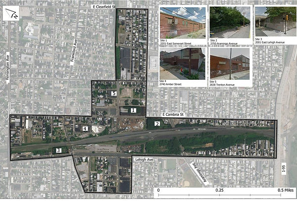
The 181-acres project area is located in North Kensington/North of Lehigh neighborhood, within the River Wards Planning District. It includes brownfield sites adjacent to the Lehigh Viaduct, a freight rail corridor located along Lehigh Avenue, between Kensington Avenue and I-95, with the main focus between Kensington Avenue and Tulip Street. This area served as a key industrial manufacturing center and transportation hub for anthracite coal from Northwest Pennsylvania in the 19th and early-20th centuries, but experienced rapid decline when these industries left in the 1950’s and 1960’s. This left the area with problems similar to other post-industrial neighborhoods: blight, crime, general disinvestment, extensive trash from illegal dumping, and vacancy. A quarter of all parcels in the project area are vacant, representing over 40 percent of total land area.
Catalyst Sites
According to the U.S. EPA, the catalyst sites may have the strongest potential for reuse due to community interest, environmental, health, or economic concerns, and/or ability to spur additional revitalization within the project area. Here are four potential catalyst sites for our project:
-
Site 1: 2201 East Somerset Street (2.31 acres)
-
Site 2: 2750 Aramingo Avenue (2.06 acres)
-
Site 3: 2001 East Lehigh Avenue (1 acre)
-
Site 4: 2740 Amber Street (0.73 acres)
-
Site 5: 2838 Trenton Avenue (0.61 acres)

Map created by Cassie Shugart

Products
Photo Feature - Initial Community Engagement 2016
Photo Feature - Community Design Workshop 2018
Media Coverage
Star Newspaper Coverage - Community Design Workshop
Resources
Local Plans
Philadelphia River Wards District Plan (2015)
North of Lehigh Neighborhood Revitalization Plan (2013)
Lehigh-Somerset Conceptual Masterplan (2011)
New Kensington Riverfront Plan (2008)
External Resources
EPA Brownfields Area-Wide Planning Program
Brownfield Overview and Definitions
Brownfields Success Stories


Project Tasks
Existing Conditions Analysis
Environmental, Social, and Public Health Conditions Analysis
Land Market and Infrastructure Analysis
Community Outreach and Visioning
Community Meetings
Focus Group and Photo-Voice (see photos)
Scenario Development and Design
Community Design Workshops (see photos)
Development of Final Site Plans
Plan Implementation Strategies
Development of Implementation Phases
Allocation of Roles for Plan Implementation
Identification of Funding Sources
Area-Wide Plan
Draft Plan
Public Feedback
Final Plan


